Africa country theme presentation. Presentation - west africa
Africa
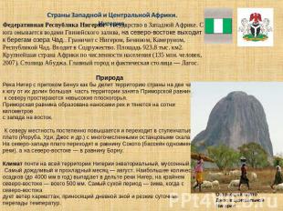
Republic of Cameroon

Republic of Cameroon
- Cameroon officially - Republic of Cameroon(from port. Rio dos Camaraes- "river of shrimp") - a state in the western part Central Africa, in the southwest washed by the waters of the Gulf of Bonny (part of the Gulf of Guinea of the Atlantic Ocean)

- The territory of the country lies north of the equator. The extreme southern point is less than 200 km away from it. The length of the coastline is about 320 km. It borders Nigeria in the northwest, Chad in the north and northeast, the Central African Republic in the east, Gabon, the Republic of the Congo and Equatorial Guinea in the south.
An unusual way to communicate

Geology of the Republic
- The relief of Cameroon is characterized by the alternation of mountains (Cameroonian mountains), plateaus and plains. Most of the Atlantic coast is occupied by an accumulative lowland (boggy in places) with wide estuaries. Standing apart on the coast is the active trachybasaltic stratovolcano Cameroon (4100 m). South of the Lobe River, the coast becomes high and rocky. In the central part of the country, blocky mountains of Adamawa rise up to 2460 m high (Chabal-Mbabo), complicated by young lava covers and cones of extinct volcanoes. To the south of these mountains are the socle denudation plateaus, which occupy most of the territory of Cameroon. To the north of the Adamawa Mountains lies an elevated stratal plain bordered to the west by the low-altitude Mandara Mountains. The extreme north of the country is occupied by the lacustrine-accumulative plain of the basin of Lake Chad, which is flooded during the rainy season. The extreme southeast of Cameroon lies on the outskirts of the Congo Basin.

Climate
- The climatic conditions of Cameroon differ in different parts of the country. In the south, the climate is equatorial, constantly humid, in the center and north - subequatorial, with rainy summers and dry winters (the duration of the dry season from south to north increases from 4 to 7 months). The western and southwestern slopes of the Cameroon volcano are the wettest place in Africa (up to 9655 mm of precipitation per year) and one of the wettest places in the world

Hydrology
- The dense and high-water river network of Cameroon belongs to the Atlantic Ocean basin, with the exception of the extreme north and northeast, the rivers of which flow into Lake Chad. The largest river, the basin of which is entirely in Cameroon, is the Sanaga. Rivers originating on the northern slopes of the Adamawa Mountains flow into the Benue, which is the main tributary of the Niger. Rivers flowing southeast flow into the Sanga, which belongs to the Congo basin. For hydropower needs, large reservoirs have been created: Mbakau, Lagdo, Bamenjing
Flora
- Forests and light forests occupy about half of the country's territory. Almost all tropical tree species grow in the Cameroonian forests. The most typical are ficuses, breadfruit, eucalyptus, palm trees. Many valuable breeds that are in demand on the world market: different kinds mahogany, such as akazhu, sipo, sapele; ebony, yellow wood and others, which provide valuable ornamental and construction wood. There are many species of trees with exceptionally hard (heavy) wood, among them one of the types of the famous iron tree - azobe; its wood is used in port facilities and for the manufacture of sleepers. Vegetation density increases from north to south: as one moves away from Lake Chad, desert savannas give way to typical ones, which are replaced in the central part of the country by light forests and deciduous-evergreen forests, which are replaced in the south by moist evergreen equatorial forests with one of the highest levels of biodiversity in Africa. On the slopes of the Cameroon volcano, mountain evergreen forests above 3000 m are replaced by mountain meadows. Mangroves grow along the coast

Fauna
- The fauna is represented by 1000 species of birds, over 300 species of mammals, 200 species of reptiles. A variety of primates live in the forests (monkeys, galagos, pottos, colobuses, drills, chimpanzees, gorillas), elephants, hippos, markhorned antelopes (bongos, sitatunga). Giraffes, buffaloes, antelopes, black rhinoceros, ostriches, marabou, bustards are numerous in the savannas, lions and leopards are found. The aquatic fauna is also rich. More than 130 species of fish are found in coastal waters, among which there are many valuable commercial species, as well as crabs, shrimps, and lobsters. The goliath frog, the largest living frog, lives in the forests of the coastal strip. The rivers of the Wuri, Sanaga, Nyong basins are rich in freshwater fish


Population
- There are about 250 ethnic groups in the country. The largest are Fang (21%), Bamileke (19%), Duala (11%), Fulbe (10%), Tikar (7%)
- Official languages - French and English
- Religions - 40% Aboriginal, 40% Christian, 20% Muslim
- Literacy - 77% of men, 60% of women

5 largest cities
- Douala - 2,132,000
- Yaounde - 1,812,000
- Garua - 573,000
- Bamenda - 546,000
- Maroua - 437,000

slide 1
African countries.
The work was done by a student of the 7th grade of the secondary school, village of Uktur, Komsomolsk district Khabarovsk Territory Alena Verkhovtseva Head: Natalya Nikolaevna Telmanova

slide 2

slide 3
North African countries. Algeria.
Algerian People's Democratic Republic, state in North Africa, refers to the countries of the Maghreb. From the north it is washed by the Mediterranean Sea, it borders on Tunisia, Libya, Niger, Mali, Western Sahara, Mauritania and Morocco. The area is 2381.7 thousand km2. Population 33.3 million (2007). Capital of Algiers.
Nature The north of the country occupies the central part of the Atlas Mountains. In the south of the country is the Sahara desert (Algeria accounts for most of its territory). Rocky deserts are called hamads, and sandy ones are called ergs. In the south, in the Ahaggar highlands, there is the city of Tahat (3003 m), the highest point of the country. The climate of Northern Algeria is subtropical Mediterranean. The climate of the Algerian Sahara is tropical desert, with less than 50 mm of precipitation per year. The river network is poorly developed (the largest is the Shelif River). Most watercourses do not have a permanent flow. The vegetation cover and soils of Northern Algeria are typically Mediterranean. Among the forests and shrubs, cork oak massifs stand out (mainly in the Tel Atlas mountains); in the semi-desert - alpha grass. Significant areas of the Sahara are devoid of vegetation. National parks: Djurdjura, Akfadu, Tassilin-Ajer, etc.
Algerian Atlas.

slide 4
The population of Algeria The majority (approx. 80%) of the population are Arabs. OK. 20% - Berbers, descendants of the ancient population of Algeria, consisting of several tribes, loosely connected with each other. Nomadic tribes live in the desert, ch. arr. Tuareg. The official language is Arabic, French is widely spoken. The state religion is Islam, the vast majority of the population are Sunnis. More than 95% of us live in Northern Algeria. countries, mainly on the narrow coastal strip and in the massifs of Kabylia. Urban population 56%. The density is 13.8 people/km2. There are large communities of Algerian Arabs in France, Belgium, and the USA. Economy Agricultural country. Cultivated mainly cereals, grapes, vegetables, fruits. Wine is produced for export. In semi-desert areas - the collection and primary processing of alpha grass, which is used to produce the best grades of paper. 95% of export earnings come from the sale of oil and gas.

slide 5
West and Central African countries. Nigeria.
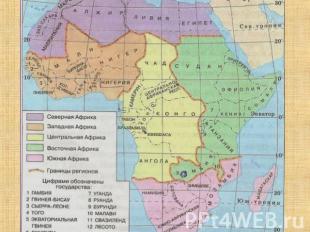
The Federal Republic of Nigeria is a state in West Africa. From the south it is washed by the waters of the Gulf of Guinea, in the northeast it goes to the shores of Lake Chad. It borders on Niger, Benin, Cameroon, and the Republic of Chad. Included in the Commonwealth. The area is 923.8 thousand km2. The largest country in Africa in terms of population (135 million people, 2007). Capital Abuja. The main city and de facto capital is Lagos. Nature The Niger River with the Benue tributary divides the country into two parts: to the south of their valleys, most of the territory is occupied by the Maritime Plain, and low plateaus extend to the north. The coastal plain is formed by sediments of rivers and stretches for hundreds of kilometers from west to east. To the north, the terrain gradually rises and passes into stepped plateaus (Yoruba, Udi, Jos, etc.) with numerous remnant rocks. In the northwest, the plateaus merge into the Sokoto Plain (basin of the river of the same name), and in the northeast into the Bornu Plain. The climate of almost the entire territory of Nigeria is equatorial, monsoonal. The rainiest and coolest month is August. The greatest amount of precipitation (up to 4000 mm per year) falls in the Niger Delta, in the extreme northeast - only 500 mm. The driest period is winter, when the harmattan wind blows from the northeast, bringing the heat of the day and sharp diurnal temperature changes.
A remnant on the Jos Plateau in central Nigeria.

slide 6
Nigeria is characterized by savannahs and tropical forests, which are common only in the Maritime Plain and in river valleys. In the north of the forest zone - deciduous dry tropical forests. Almost half of the country's territory is occupied by tall-grass (wet Guinean) savannah with rare trees - kaya, isoberlinia, mitragina. To the north of the zone of tall grass savannah, the dry Sudanese savannah stretches with umbrella acacias, baobabs and thorny bushes. In the extreme northeast of the country, the Sahelian savanna with sparse vegetation stretches. And only off the shores of Lake Chad is an abundance of lush greenery, thickets of reeds and papyrus. The fauna of Nigeria is also diverse, preserved in national parks and reserves. Elephants, giraffes, rhinos, leopards, hyenas, numerous antelopes (including the forest dwarf dikdik antelope) are widespread, large herds of buffalo are found, in some places the scaly anteater, chimpanzee and gorilla, monkeys, baboons, pottos have been preserved. The world of birds is rich in forests, savannahs, especially along river banks.

Slide 7
Population Ethnic composition: more than 250 nationalities and groups, the most numerous: Fulani and Hausa 29%, Yoruba 21%, for 18%, Ijo 10%, Ibibio 3.5%, Tiv 2.5%, Bini, etc. About 50% believers - Muslims, 40% - Christians (mostly Protestants), 10% - adhere to traditional beliefs. The official language is English. The resettlement of peoples and tribes does not coincide with the division of the country into states. This has repeatedly led to armed conflicts. There is a difference between Christians and Muslims. The population density is 144.9 people/km2. Urban population 39%. Economy Nigeria's economy is based on the oil industry and agriculture. Tin, limestone and natural gas, tungsten, tantalum, thorium, zircon, uranium, polymetallic ores, gold, etc. are mined in significant quantities. Up to 50% of the economically active population is employed in agriculture. Cocoa, rubber and palm kernels are the only export crops. For domestic consumption, cassava, yams and sweet potatoes, sorghum and millet, corn, rice, peanuts, oil palm, and cotton are grown. An important role in crop production is played by the cultivation of legumes, sugarcane, vegetables and fruits. Harvest of peanut Animal husbandry is extensive. OK. 90% of livestock is concentrated in the northern part of the country (where there is no tsetse fly). The traditional dressing of leather is preserved, the leather made from goats is especially valued - “red morocco”. Own production not enough to feed a rapidly growing population and Nigeria is a food importer, especially grains. Approximately an eighth of the country is covered with forests and the country has the necessary potential for the development of the forest industry, but predatory deforestation has hampered the development of this industry and has been the cause of catastrophic droughts since the 1960s. Despite the growth in production, the manufacturing industry remains largely small-scale. With the help of the USSR, a metallurgical plant was built in Ajaokuta. The assembly lines of the Volkswagen, Peugeot, and Fiat factories are functioning. The monetary unit is the naira.
Sacks of peanuts stacked in a pyramid.
Pumping station oil pipeline.

Slide 8
East African countries. Ethiopia.
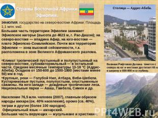
ETHIOPIA, a state in northeastern Africa. The area is 1.1 million km2. Most of the territory of Ethiopia is occupied by the Ethiopian Highlands (height up to 4623 m, Ras Dashen); in the northeast - the Afar depression, in the southeast - the Ethiopian-Somali plateau. Almost the entire territory of Ethiopia is a zone of high seismicity, tk. located in the Great African Rift. The climate is tropical desert and semi-desert in the northeast, subequatorial in the rest. Average monthly temperatures are 13-18 °C (Addis Ababa). Precipitation is from 150-600 to 1500-1800 (in some places less than 50) mm per year. Large rivers - the Blue Nile, Atbara, Vebi-Shebeli. Shrub deserts, semi-deserts, deserted savannahs. In the southwest - tropical rainforests. National parks - Awash, Gambela, Simen, etc. Population 76.5 million people (2007), mainly Amhara peoples (about 40% of the population), Oromos (over 40%), Tigrays and others (more than 100 peoples) . The official language is Amharic. Most of the believers are Muslims and Christians.
The Great Rift Valley stretches from north to south and in some places reaches 65 km wide and 600-900 m deep.
The capital is Addis Ababa.

Slide 9
Ethiopia is an agricultural country.
Main industry Agriculture- crop production. Crops of grain, leguminous, oil-bearing crops; the main export crop is coffee. Animal husbandry: breeding of cattle, sheep and goats. Fishing. Handicraft production is developed: weaving, processing of leather, bone, wood, etc. Branches industrial production: mining (platinum, gold mining), oil refining, metalworking industry, light industry, food industry, Electricity production 1.3 billion kWh (1995). The largest hydroelectric power station is Fincha (100 MW). Length railways 0.78 thousand km (1993), roads - 28.3 thousand km (1996). Ports: Massawa, Assab; international trade mostly goes through the port of Djibouti. Main foreign trade partners: USA, European Union countries, Japan, Russia. Monetary unit - birr.

Slide 10
South African countries South Africa is a country of gold and diamonds.
Cape Town
SOUTH AFRICAN REPUBLIC (South Africa) is a state in southern Africa. The area is 1.2 million km2. The capital - Pretoria, the seat of parliament - Cape Town of South Africa occupies the southern outskirts of the South African Plateau, elevated along the edges (Dragon Mountains in the east, individual peaks over 3000 m) and limited by the steep slopes of the B. Ledge. To the south are the Cape Mountains.
The climate is tropical and subtropical. The average temperature in January is 18-27 °С, in July 7-10 °С. Precipitation is from 60 mm on the coast, 650 mm on the plateau and up to 2000 mm per year on the eastern slopes of the Drakensberg Mountains. The main rivers are Orange and Limpopo. In the east - savannah, south of 30 ° S. sh. - subtropical forests and hard-leaved evergreen shrubs, on the slopes of the mountains - subtropical and monsoon forests; in the interior, deserted savannah, steppes, semi-deserts and the Karoo desert. National parks - Kruger, Kalahari-Gemsbok and others, numerous nature reserves and reserves.

slide 11
Population and economy of South Africa
Population 43.99 million people (2007), including Africans (76%; Zulu, Xhosa, etc.), Mestizos (9%), Europeans (13%), mainly Afrikaners (Boers) and the English. Urban population 55.4% (1996). The official language is Afrikaans and English. Believers are mostly Christians and adherents of local traditional beliefs
South Africa is an industrial-agrarian country with a high level of economic development, the most economically developed state in Africa. South Africa occupies one of the first places in the world in the extraction of gold, platinum, chromites, manganese ore, antimony, and diamonds. mining uranium, iron ore, copper, asbestos, etc. Ferrous metallurgy, mechanical engineering, chemical, oil refining, cement, textile, food industry. In agriculture, commercial products are produced by large farms. The basis of agriculture is animal husbandry: sheep and goats, large cattle. Main agricultural crops: corn, wheat, sugar cane. Sorghum, peanuts, tobacco, citrus and grapes, sunflower, etc. are also cultivated. seaports: Durban, Cape Town, Port Elizabeth, East London The country is experiencing a tourism boom, with billions of dollars in tourism revenue. Exports: mineral and agricultural raw materials, agricultural products, diamonds, mining equipment. Main foreign trade partners: Great Britain, USA, Germany, Japan. The monetary unit is the South African rand.
West Africa

West Africa
- part of the African continent, located south of the central Sahara and washed from the west and south by the Atlantic Ocean. The natural border in the east is the Cameroon Mountains.

Story
Before the arrival of Europeans in West Africa, there were states - Ghana, Mali and Songhai. In the 15th century, the Portuguese began to establish their colonies on the Guinean coast, later the French and the British.

States included in West Africa
Mali Niger Nigeria Benin Burkina Faso Ghana Ivory Coast Gambia Sierra Leone Togo
Guinea Guinea-Bissau Cape Verde Cameroon Liberia Mauritania Saint Helena, Ascension and Tristan da Cunha Senegal

natural conditions
The nature of the Western sub-region of Africa feels the great influence of the Sahara desert, which is located in the north. The transitional areas from the desert to the savannah are called the Sahel, within which precipitation falls, but it is less than 200 mm per year. South of the Sahel, a strip of savannas and forest avannas passes through the entire region, then there is a forest zone. The geological conditions of this region are calm.

Mineral resources
There are many mineral resources in West Africa, however, they have been mined only recently. The following ores are found in local bowels: iron, aluminum, tungsten, manganese, uranium, chromium, tin and valuable metals

Infrastructure
The road infrastructure is poorly developed, railways exist only from the hinterland to the coast and are a legacy of colonial economic policy. Significant ports are Dakar, Conakry, Abidjan, Accra, Lome and Lagos.

Economy
The states are among the poorest countries in the world, Nigeria, despite rich oil reserves, is also far behind in development. On the coast, agriculture produces monocultures intended for export. Most West Africans are self-sufficient.

Population
The border of the settlement of representatives of two large races - Caucasoid and Negroid - passes through the territory of the region. In the northern regions, on the territory of Mali and Niger, Berber-speaking Tuareg live. However, the vast majority of the peoples of West Africa belong to the large Negroid race.

culture
West Africa is home to more than half of the African languages. Most of them belong to the Kongo-Kordofanian and Afroasiatic language group.
1 slide

2 slide
Lesotho The Kingdom of Lesotho is renowned for the breathtaking beauty of its mountain scenery. The source of wealth is tourists from South Africa, agriculture - corn, wheat, vegetables.

3 slide
Mali Mud-built houses and grain barns in the Dogon villages of eastern Mali huddle together. Today, the north of Mali is considered the hottest and driest region of the Earth. They are engaged in agriculture: rice, millet, peanuts, tea, cotton, animal husbandry, fishing.

4 slide
Bamako - a city in Mali Life in this city is largely determined by religion, whose name is Islam. Busy trade in textiles, oriental perfumes, spices, poultry and jewelry. Every Friday, thousands of Muslims in colorful festive clothes to look towards Mecca, to offer a prayer to the Almighty.

5 slide
Malawi The fertile shores of Malawi are densely populated. The Yao people mainly live here, as well as the Sena, Cheva, Ngoni people. The average life expectancy of humans is 41 years. Occupations: Agriculture: tobacco, vegetables, cotton, tea, sugar cane, corn. Fishing. Industry - cement, consumer goods, electricity.

6 slide
Mauritania 3/4 of the entire country is located on the western tip of the Sahara, but the sand dunes continue their advance inland, forcing many nomads to a settled way of life. The most precious thing for the inhabitants is water, the country suffers from constant drought. Development: mining, leather industry, beans, dates, rice.

7 slide
Morocco The artificially irrigated oasis city of Tiznit lies right in the middle of the desert. On the horizon you can see the Anti-Atlas mountain range stretching for many kilometers. Make a trip to Morocco is worth at least for the sake of nature. In this country you will find beautiful beaches, snowy peaks, desert landscapes that will take your breath away.

8 slide
Agadir - Moroccan Beach Resort a large number of tourists from Europe. For them, along the coast there is a vast zone of comfortable hotels and beach complexes. In 1960, a powerful earthquake left no stone unturned from the city (in 15 seconds).

9 slide
Niger Most of the territory is occupied by sandy deserts. Vegetation is extremely rare. One of the largest and sparsely populated countries in Africa. The river flows only at the extreme South-West countries. Big hopes in this poor country are pinned on uranium deposits. Agriculture: millet, rice, cotton, peanuts, dates, vegetables, livestock.


1 of 11
Presentation on the topic: African countries
slide number 1

Description of the slide:
slide number 2
Description of the slide:
slide number 3

Description of the slide:
North African countries. Algeria. The Algerian People's Democratic Republic, a state in North Africa, belongs to the countries of the Maghreb. From the north it is washed by the Mediterranean Sea, it borders on Tunisia, Libya, Niger, Mali, Western Sahara, Mauritania and Morocco. The area is 2381.7 thousand km2. Population 33.3 million (2007). Capital of Algiers. Nature The north of the country occupies the central part of the Atlas Mountains. In the south of the country is the Sahara desert (Algeria accounts for most of its territory). Rocky deserts are called hamads, and sandy ones are called ergs. In the south, in the Ahaggar highlands, there is the city of Tahat (3003 m), the highest point of the country. The climate of Northern Algeria is subtropical Mediterranean. The climate of the Algerian Sahara is tropical desert, with less than 50 mm of precipitation per year. The river network is poorly developed (the largest is the Shelif River). Most watercourses do not have a permanent flow. The vegetation cover and soils of Northern Algeria are typically Mediterranean. Among the forests and shrubs, cork oak massifs stand out (mainly in the Tel Atlas mountains); in the semi-desert - alpha grass. Significant areas of the Sahara are devoid of vegetation. National parks: Djurdjura, Akfadu, Tassilin-Ajer, etc.
slide number 4

Description of the slide:
The population of AlgeriaThe majority (approx. 80%) of the population are Arabs. OK. 20% - Berbers, descendants of the ancient population of Algeria, consisting of several tribes, loosely connected with each other. Nomadic tribes live in the desert, ch. arr. Tuareg. The official language is Arabic, French is widely spoken. The state religion is Islam, the vast majority of the population are Sunnis. More than 95% of us live in Northern Algeria. countries, mainly on the narrow coastal strip and in the massifs of Kabylia. Urban population 56%. The density is 13.8 people/km2. There are large communities of Algerian Arabs in France, Belgium, and the USA. EconomyAgrarian country. Cultivated mainly cereals, grapes, vegetables, fruits. Wine is produced for export. In semi-desert areas - the collection and primary processing of alpha grass, which is used to produce the best grades of paper. 95% of export earnings come from the sale of oil and gas.
slide number 5
Description of the slide:
West and Central African countries. Nigeria. The Federal Republic of Nigeria is a state in West Africa. From the south it is washed by the waters of the Gulf of Guinea, in the northeast it goes to the shores of Lake Chad. It borders on Niger, Benin, Cameroon, and the Republic of Chad. Included in the Commonwealth. The area is 923.8 thousand km2. The largest country in Africa in terms of population (135 million people, 2007). Capital Abuja. The main city and de facto capital is Lagos. Nature The Niger River with its tributary Benue divides the country into two parts: to the south of their valleys, most of the territory is occupied by the Maritime Plain, and low plateaus extend to the north. The coastal plain is formed by sediments of rivers and stretches for hundreds of kilometers from west to east. To the north, the terrain gradually rises and passes into stepped plateaus (Yoruba, Udi, Jos, etc.) with numerous remnant rocks. In the northwest, the plateaus pass into the Sokoto Plain (the basin of the river of the same name), and in the northeast - into the Bornu Plain. The climate in almost the entire territory of Nigeria is equatorial, monsoon. The rainiest and coolest month is August. The greatest amount of precipitation (up to 4000 mm per year) falls in the Niger Delta, in the extreme northeast - only 500 mm. The driest period is winter, when the harmattan wind blows from the northeast, bringing the heat of the day and sharp diurnal temperature changes. A remnant on the Jos Plateau in central Nigeria.
slide number 6

Description of the slide:
Nigeria is characterized by savannahs and tropical forests, which are common only in the Maritime Plain and in river valleys. In the north of the forest zone - deciduous dry tropical forests. Almost half of the country's territory is occupied by tall-grass (wet Guinean) savannah with rare trees - kaya, isoberlinia, mitragina. To the north of the zone of tall grass savannah, the dry Sudanese savannah stretches with umbrella acacias, baobabs and thorny bushes. In the extreme northeast of the country, the Sahelian savanna with sparse vegetation stretches. And only off the shores of Lake Chad is an abundance of lush greenery, thickets of reeds and papyrus. The fauna of Nigeria, preserved in national parks and reserves, is also diverse. Elephants, giraffes, rhinos, leopards, hyenas, numerous antelopes (including the forest dwarf dikdik antelope) are widespread, large herds of buffalo are found, in some places the scaly anteater, chimpanzee and gorilla, monkeys, baboons, pottos have been preserved. The world of birds is rich in forests, savannahs, especially along river banks.
slide number 7

Description of the slide:
Population Ethnic composition: over 250 nationalities and groups, the most numerous: Fulani and Hausa 29%, Yoruba 21%, for 18%, Ijo 10%, Ibibio 3.5%, Tiv 2.5%, Bini, etc. About 50% of believers - Muslims, 40% - Christians (mostly Protestants), 10% - adhere to traditional beliefs. The official language is English. The resettlement of peoples and tribes does not coincide with the division of the country into states. This has repeatedly led to armed conflicts. There is a difference between Christians and Muslims. The population density is 144.9 people/km2. Urban population 39%. Economy The economy of Nigeria is based on the oil industry and agriculture. Tin, limestone and natural gas, tungsten, tantalum, thorium, zircon, uranium, polymetallic ores, gold, etc. are mined in significant quantities. Up to 50% of the economically active population is employed in agriculture. Cocoa, rubber and palm kernels are the only export crops. For domestic consumption, cassava, yams and sweet potatoes, sorghum and millet, corn, rice, peanuts, oil palm, and cotton are grown. An important role in crop production is played by the cultivation of legumes, sugarcane, vegetables and fruits. Harvest of peanuts Animal husbandry is extensive. OK. 90% of livestock is concentrated in the northern part of the country (where there is no tsetse fly). The traditional dressing of leather is preserved, the leather made from goats is especially valued - “red morocco”. Domestic production is not enough to feed a rapidly growing population and Nigeria is an importer of food, especially grain. Approximately an eighth of the country is covered with forests and the country has the necessary potential for the development of a forest industry, but predatory deforestation hinders the development of this industry and has been the cause of disastrous droughts since the 1960s. -s Despite the growth in production, the manufacturing industry remains largely small-scale. With the help of the USSR, a metallurgical plant was built in Ajaokuta. The assembly lines of the Volkswagen, Peugeot, and Fiat factories are functioning. The monetary unit is the naira. Oil pipeline pumping station. Sacks of peanuts stacked in a pyramid.
slide number 8
Description of the slide:
East African countries. Ethiopia. ETHIOPIA, a state in northeastern Africa. The area is 1.1 million km2. Most of the territory of Ethiopia is occupied by the Ethiopian Highlands (height up to 4623 m, Ras Dashen); in the northeast - the Afar depression, in the southeast - the Ethiopian-Somali plateau. Almost the entire territory of Ethiopia is a zone of high seismicity, tk. located in the zone of the Great African Rift. The climate is tropical desert and semi-desert in the northeast, subequatorial - in the rest. Average monthly temperatures are 13-18 °C (Addis Ababa). Precipitation is from 150-600 to 1500-1800 (in some places less than 50) mm per year. Large rivers - the Blue Nile, Atbara, Vebi-Shebeli. Shrub deserts, semi-deserts, deserted savannahs. In the southwest - tropical rainforests. National parks - Awash, Gambela, Simen, etc. Population 76.5 million people (2007), mainly Amhara peoples (about 40% of the population), Oromos (over 40%), Tigrays and others (more than 100 peoples) . The official language is Amharic. Most of the believers are Muslims and Christians. The Great Rift Valley stretches from north to south and in some places reaches 65 km wide and 600-900 m deep.
slide number 9

Description of the slide:
Ethiopia is an agricultural country. The main branch of agriculture is crop production. Crops of grain, leguminous, oil-bearing crops; the main export crop is coffee. Animal husbandry: breeding of cattle, sheep and goats. Fishing. Handicraft production is developed: weaving, processing of leather, bone, wood, etc. Industrial production sectors: mining (platinum, gold mining), oil refining, metalworking industry, light, food, Electricity production 1.3 billion kWh (1995 ). The largest hydroelectric power station is Fincha (100 MW). The length of railways is 0.78 thousand km (1993), roads - 28.3 thousand km (1996). Ports: Massawa, Assab; foreign trade mostly goes through the port of Djibouti. Main foreign trade partners: USA, countries of the European Union, Japan, Russia. Monetary unit - birr.
slide number 10

Description of the slide:
South African countriesSouth Africa is a country of gold and diamonds. SOUTH AFRICAN REPUBLIC (South Africa) is a state in southern Africa. The area is 1.2 million km2. The capital - Pretoria, the seat of parliament - Cape TownSouth Africa occupies the southern outskirts of the South African plateau, elevated along the edges (Dragon Mountains in the east, individual peaks over 3000 m) and limited by the steep slopes of the B. Ledge. To the south are the Cape Mountains. The climate is tropical and subtropical. The average temperature in January is 18-27 °С, in July 7-10 °С. Precipitation is from 60 mm on the coast, 650 mm on the plateau and up to 2000 mm per year on the eastern slopes of the Drakensberg Mountains. The main rivers are Orange and Limpopo. In the east - savannah, south of 30 ° S. sh. - subtropical forests and hard-leaved evergreen shrubs, on the slopes of the mountains - subtropical and monsoon forests; in the interior, deserted savannah, steppes, semi-deserts and the Karoo desert. National parks - Kruger, Kalahari-Gemsbok and others, numerous nature reserves and reserves.
slide number 11

Description of the slide:
Population and economy of South Africa Population 43.99 million people (2007), including Africans (76%; Zulu, Xhosa, etc.), mestizos (9%), immigrants from Europe (13%), mainly Afrikaners (Boers) and the British. Urban population 55.4% (1996). The official language is Afrikaans and English. Believers are mostly Christians and adherents of local traditional beliefs. South Africa is an industrial-agrarian country with a high level of economic development, the most economically developed state in Africa. South Africa occupies one of the first places in the world in the extraction of gold, platinum, chromites, manganese ore, antimony, and diamonds. Uranium, iron ore, copper, asbestos, etc. are mined. Ferrous metallurgy, mechanical engineering, chemical, oil refining, cement, textile, and food industries. In agriculture, marketable products are produced by large farms. The basis of agriculture is animal husbandry: sheep and goats, cattle. Main agricultural crops: corn, wheat, sugar cane. Sorghum, peanuts, tobacco, citrus and grapes, sunflower, etc. are also cultivated. The length of roads (1996, thousand km): railways 21.6, paved roads 54. The most important seaports: Durban, Cape Town, Port Elizabeth, East London The country is experiencing a tourism boom, with billions of dollars in tourism revenue. Exports: minerals and agricultural raw materials, agricultural products, diamonds, mining equipment. Main foreign trade partners: Great Britain, USA, Germany, Japan. Monetary unit - South African rand.